Overview
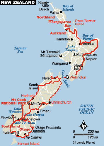
In 2005, there were a couple of real changes from the first 2 times we toured New Zealand. First, the tourists of the world and New Zealand have discovered this jewel of nature. The accommodations are full, the prices are way up and the roads are crowded especially around the main tourist attractions. Other things can’t change. The natural beauty and grandeur, the dearth of crime and the Kiwis themselves. Our overall rating has dropped mainly because of the above mentioned changes. Finally, a few notes that could help: 1) Absolutely, for sure, get the Kiwi written Peddlers Paradise 2) Take a mountain bike to escape the busier, narrow highways 3) Realize that the usual Kiwi driver does not give you space when passing (it’s better with the tourists who do give you your space) 4) Be sure to go east at the bottom of the South Island where the winds can blast out of the west. 5) The afternoon winds on the east coast (i.e. Christchurch) blow inland so this gives you a push if you head west here. (all other areas are more variable for the winds) Our greatest days (also perfect weather) of biking were into Mt Cook from Twizel, into Milford from TeAnu, the East Cape and finally the less spectacular but tourist free quiet road that is Hwy 52 on the North Island, here it was the land of the Kiwis.
How We Rate This Trip
Roads: 5
The paved roads are good and are being constantly improved. The main highways are often too busy and narrow. There are seldom rideable shoulders so its best to stick to the secondary paved roads and these are not that plentiful. We rode road bikes. We should have taken mountain bikes so we could have used the gravel and dirt roads.
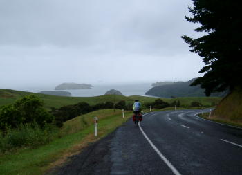
Cotoromandel Peninsula – North Island
Traffic: 6
Since our last trip, the amount of traffic has quadrupled. The main highways are too busy and narrow to bike. Any peninsula (except the Coromandal at Christmas time) is better riding. The south island has less population but is overwhelmed with tourists. The best quiet riding is Hwy 52 and the East Cape on the north island and the scenic southern rout (Catlins etc.) on the south island.
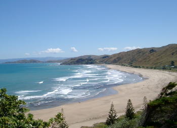
East Cape Peninsula – North Island
Weather: 3
You are never far from the sea so the weather is ever changing. The east coast of the North Island was kind to us. Warm and sunny for days. Some days were even hot! The very south of the South Island seldom warms and we almost never saw the sun. Cold fronts rush through and will change the temperature in a split second. In late December all of New Zealand was cold and wet including the Coromandal. After January 5th, summer came with temperatures in the high 20’s and even 30 in Gisborne. Then in a flash it changed at the end of February to wet and cold and finally warmed again about March 10. It’s all a matter of luck.
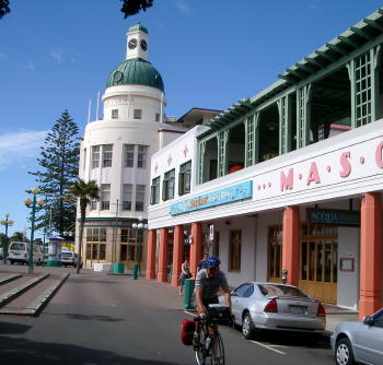
North Island – Napier, an Art Deco Town
Winds: 3
There are the predictable overall patterns and then there are the areas where its basically a 50-50 proposition. The predictable pattern is in the very south of the South Island where the winds are almost always from the west and can howl. The winds on the east coast of the south island blow easterly in the afternoon and on the west coast, the winds are also off the sea. But they can have a northerly or southerly vector. The best way to take advantage of the winds on the south island is to go Picton-Christchurch-inland to Alexandra & Wanaka to Queenstown and Milford, south to Riverton and Invercargil, the Catlins then Dunedin then back to Wanaka to the west coast then to Nelson and back to Picton (a figure 8).
Scenery: 9
Many call New Zealand the most beautiful country in the world. Perhaps, but sometimes there are rather dull interludes between highlights. Even on the west coast of the South Island there are stretches of ordinary scenery punctuated by the spectacular. Not to be missed is the east side of the Coromandal Peninsula, the East Cape, and the usual places like Mt. Cook and Milford Sound on the South Island.
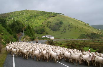
Hwy 52, A great ride, sheep keep the traffic slow – North Island
Information: 9
Yes, the tourist offices are very helpful and usually offer local and regional maps. They’ll also help with accommodations and even book a room for you. There are plenty of guidebooks like Lonely Planet and the Rough Guide. There are AA publications listing all accommodations with prices, pictures and phone numbers. All very easy. This is especially important since New Zealand, especially the South Island, is overrun with tourists in the summer season. But the best information on the roads for biking comes in the essential, Kiwi written Peddlers Paradise. It has descriptions, distances and a graphic of the grades to be climbed. It only lacks a definitive measure of traffic, the road width and available shoulders and scenery. We try to describe these in more detail expecting the cyclist to use the Peddlers Paradise. Lonely Planet also offers a bike specific guide. This helps in getting an overall plan for your tour.
Road Safety: 6
The Kiwi drivers simply don’t respect your space. Both cars and trucks brush past you too closely. Actually, in the most touristic areas, we felt better because the tourists in their rented cars and vans have a far better understanding of giving the cyclist enough room. Almost all the highways have no shoulders so the big traffic (trucks, busses etc.) have little room to give you. That being said, you know that the drivers do care for your safety.
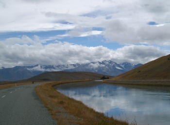
South Island – Canal Road near Tekapo
General Safety: 10
Once out of Auckland, there seemed to be no risk to you, your bike or your luggage. No place is perfectly crime free but New Zealand is as close as you can get. We frequently parked our bikes at stores or restaurants or motels and simply left them unlocked and un watched. We never had a problem. We never locked our bikes at night but sometimes put them in an available shed or garage for the night. It’s how the world should be but seldom is.
Value: 3
Its been 15 years since we last came to New Zealand. Probably the biggest change is how expensive it has become. It’s a combination of the dollar slipping, the New Zealand economy picking up , the large growth in tourism and the Kiwi retailer who will to take big margins. The prices of the simple things like toothpaste or bike tubes or tires or sun screen or bug repellent will shock you. It will cost 2, 3 even 4 times as much as in the US. Food, accommodations, drinks etc will cost about 50% higher than in the States. If you do your homework or camp etc, you will save massively.
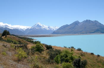
Mt. Cook in all her glory! – South Island
Fluids: 8
The tap water almost everywhere except the most rural outposts is potable. We never bought water. For soda etc, the best purchase is the large bottles (1.5 liters) which cost just a bit more than the small bottles. We shared these. Also, energy drinks came in ½ liter sizes. Coffee is now a prized beverage. High quality Lattes and Cappuccinos are good but expensive. There’s lots of good New Zealand wine. The Kiwi beer tends to the sweet side but there were occasional micro brews that we enjoyed. All of these are pricy.
Food: 7
We enjoyed places like Motels which had kitchenettes for breakfast fixing of cereal and coffee. Lunch was usually a steak and cheese pie. For dinner, in all cities of some size we found very good Indian or Thai restaurants. Otherwise, it was Pub meals: steak or lamb or fish at higher prices but in large portions. We only had a couple of poor meals but not overly exciting preparation.
Accomodations: 8
All types from Hostels to Hotels to backpacker dorms to Motels are all of reasonable quality. Usually, they are not fancy but well maintained. We eventually stayed in all of these mostly because of the crowds of tourists. We had to call ahead to protect ourselves. A few times we’d end up with way overpriced rooms or pretty poor quality just because it was the only room left in town. Our preference for value was the motel (Studio with kitchenette) then the hotel (a basic room sometimes ensuite) the hostel (often with a double room) and finally the B & B which was frilly and overpriced.
People: 9
The Kiwis are friendly, fun loving, approachable and still not worn down by the tourist onslaught of late. Our encounters with them were one of the highlights for us. Their self-deprecating sense of humor was a delight. They are big-hearted and unquestioningly honest. In any bind, you can count on their help! We made a lot of friends very easily. Even the tourists are nicer. It must rub off.
Culture: 3
The influence is English but there is little self-formed culture. The Maories offer an interesting South Pacific influence but their roots have long been interrupted so that now its their retro approach that you encounter. Another specifically Kiwi way of life is their large appetite for the outdoor life, thrilling pursuits and love of sport. I once asked, “Is there any Kiwi under 30 who isn’t an athlete?”
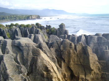
History: 5
New Zealand is a young country so the European arrival was relatively recent. Even the Maories are relative new comers with little left of their origins. The saving grace is the unique ecosystem that can still be seen. This is the land of unique species of reptiles, birds and insects. So, in effect, their short human history has left a lot of flora and fauna which is in effect a study of history.
TOTAL SCORE 94
Route Descriptions and Maps
New Zealand – North Island
Auckland to Thames (Coromandel) 115Ks
Ferry to Half Moon Bay then ride to Howick then to Whitford. All hilly and using main roads. Right in Whitford to end of road (2Ks) then right to circle at school (1K) then left to Clevedon. Join highway, right 2Ks to Clevedon. Now on Pedaller’s Paradise Book Route. Hills then to coast. Rest is flat. (We had Nor Easter so it was down wind and fast) 2 lanes, narrow but quiet, at 12/28/04 (Kiwi Holiday time). At Junction with busy main road, left. Mostly with a shoulder (sometimes not). Over a narrow one lane bridge then 5 Ks into Thames.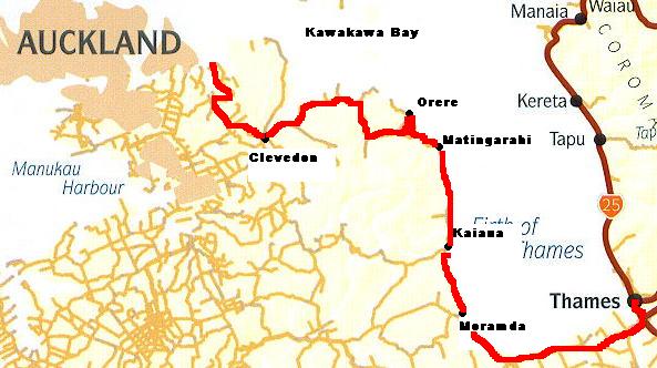
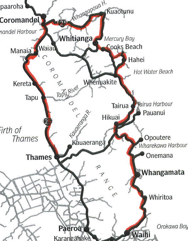
Thames to Coromandel Town 56Ks
Beautiful along coast. Narrow and busy. Lots of curves. Too much holiday traffic. After the coast cut inland and climb. No stores or shelter if it rains. (It rained!)
Coromandel Town to Whitianga 45Ks
Optional road before Kuaotuna is partly gravel. Hill after turn off on Hwy 25 is very steep up for .75Ks
Whitianga to Hahei 15Ks
Ferry then 12Ks on minor road. Somewhat busy, though, at Holiday time. Rolling then left to Hahei. Gradual rolling hills.
Hahei to Whangamata 60Ks
10Ks back to Hwy 25, some holiday traffic. Rolling, 2-lanes and no shoulder. Left on Hwy 25 mostly no shoulder, lots of traffic, hill before Tairua is gradual near top. Narrow with an on and off shoulder. Very busy with Holiday traffic. Bad ride. Next climb had moderate grade.
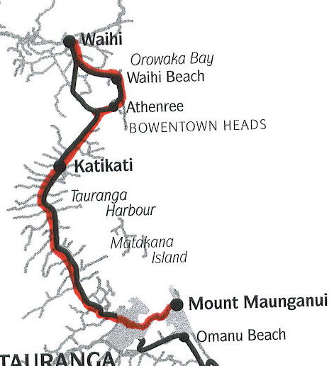
Whangamata to Tauranga 92Ks
Narrow no shoulder, busy with holiday traffic. Hill before Waihi: 236 meters. Mostly gradual but long (4Ks up). Waihi at 30Ks then left on Hwy 2. A shoulder & easy rolling hills but lots of traffic. On expressway shoulder (legal) into town.
Tauranga to Rotorua 61Ks
Take Cameron Road out. Bike path or wide shoulder through town for 8Ks then narrower shoulder. Moderate traffic. Slightly climbing. Then there is no shoulder but lighter traffic. Views back but so-so scenery. Rolling hills. Now paved at the top. Long down to Lake Road. Right. Quiet with shoulder to Main Hwy then busy road with a shoulder into Rotorua.
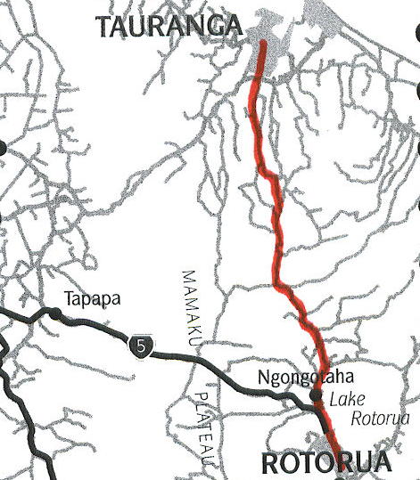
(**We started to ride to Taupo – Busy highway riding, uninteresting scenery, not worth it so we turned back)
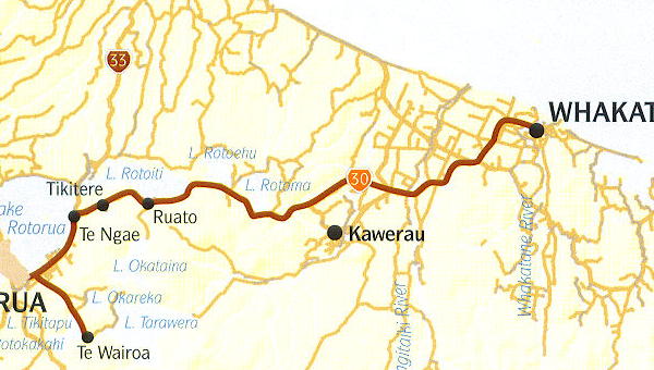
Rotorua to Whakatane 87Ks
Shoulder to Hells Gate then on and off shoulder Great gradual downhill. Then flat with more traffic but with a shoulder. Good ride. Some Log Trucks and moderate traffic.
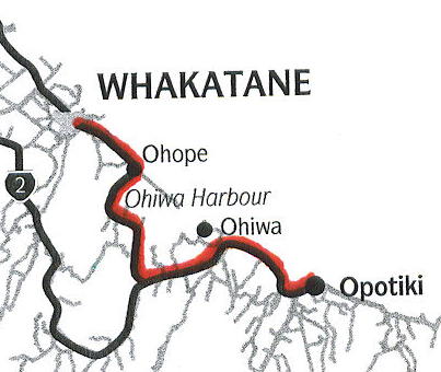
Whakatane to Opotiki 46Ks
Toward Ohope, climb on bike path reserved for up hill riders only. Nice views, narrow and busy to Hwy 2. Narrow and busy with Holiday traffic. No logging trucks at holiday time.
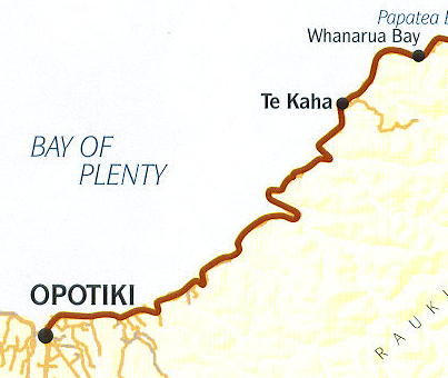
Opotiki to Te Kaha 67Ks
Beautiful ride. Even quiet at holiday time. Narrow. Curvy and hilly but with good grades. Great views.
Te Kaha to Hicks Bay 82Ks
Great ride, narrow, quiet. Great scenery. Lots of moderate hills.
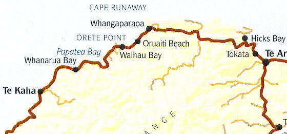
Hicks Bay to Tokomaru Bay 91Ks
Mostly inland so less dramatic scenery. Over hill to Te Araroa then up and down hills all day to Tokomaru Bay. Quiet.
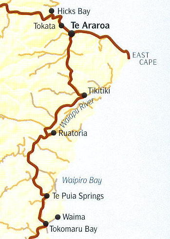
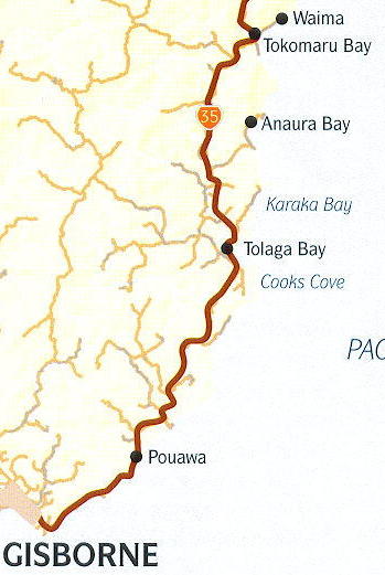
Tokomaru Bay to Gisborne 91Ks
Less hilly, some nice gradual stretches. A little busier and more trucks. Narrow but still nice riding. Inland through ranch land. Finally near the ocean going into Gisborne. More and more traffic but a wider shoulder for the last 10Ks.
(Gisborne ** Day ride through the vineyards. Flat and fun with simple maps from tourist office)
Gisborne to Wairoa 102Ks
(the inland, quiet route)
11Ks to junction for Tiniroto (best out on Gladstone Ave) straight through vineyards (good scenery). Quiet. 2-lanes, no shoulder. Start climbing to 25Ks (360 meters) views back to Gisborne, moderate grades. At 29Ks, Waerenga Store (closed Sat. & Sun) Rolling hills then cross river at 51Ks and climb to 58Ks. (2nd tough climb) about 300 meters. Then down to Tiniroto, 60Ks. Then down to TeReinga at 70Ks (98 meters) Climb for 3Ks then down to river and roll up and down to Junction Hwy 38. Then easy rolling to Wairoa. Busier into town.
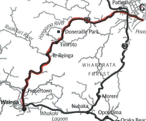
Wairoa to Napier 119Ks
Occasionally a small shoulder. Moderate traffic with trucks. Because of curves and hills traffic comes in bunches. Good scenery. Mostly moderate grades. At Bay View, 10Ks before Napier go left across railroad tracks and take minor roads and bike paths into town along coast.
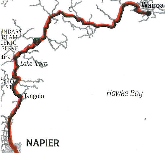
Napier to Havelock North via Hastings 25Ks
(Short day with lots of sight seeing)
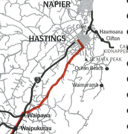
Out along Marine Parade on new bike path for 7Ks then inland to Hastings using Brookfields roads & other minor roads. The main road is busy but has a wide shoulder except the narrow bridge across the river. Then left through Hasitngs to Havelock North. There are many alternatives.
Havelock North to Waipukurau 57 Ks
(Route not described in Peddlers Paradise)
Take Middle Road. Narrow 2-lanes, very quiet through ranch country. Rolling hills then climb at 21Ks for 2 Ks. Part is steep then down to river. Slowly up the river valley on rolling hills. At 35Ks, at the Patangata Tavern, right on River road. Rolling up river. At 42Ks right toward Waipawa. Rolling up to Hwy 2 at 50Ks. More traffic including trucks. Left on Hwy 2, busy and many trucks, narrow shoulder. A bad 7Ks to Waipukurau. Worst is narrow bridge just before town. Better to take walk (walkway on right side)
Waipukurau to Porangahau 45Ks
Strong head winds ( it’s usually windy here) 2 lanes, flat for 14Ks. Pretty farm country. At 14Ks, a gradual climb then a long gradual descent. Pub at 20Ks. Rolling down. After 30Ks, it’s hillier but tending down. Off highway 500 meters to town. (It’s another flat 7 Ks to the beach)
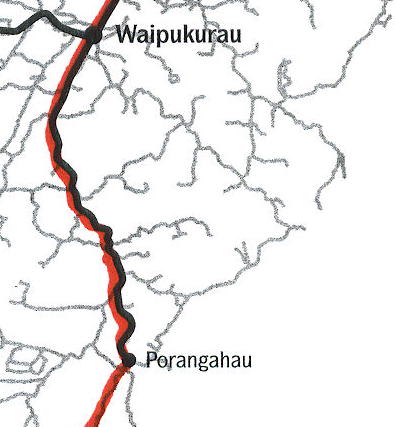
Parangahau to Pongaroa 65Ks (plus 10Ks to Glenross Hostel on Hwy 52)
All narrow 2-lane, ok scenery, quiet. Strong head winds. It’s usually windy here. ½ K climb then down and slowly climbing up a valley to 13Ks. Then 3 Ks of loose -gravel and hills (on road bikes, we walked) Hills & curves to Wimbledon (Pub) 20Ks. Mostly climb to 30Ks, some steep pulls. Then more gradual descent and rolling for 10Ks then a short steep descent to turn-off, left at 41Ks. Down along river to 53Ks, the turn off for Akito, 60Ks. Straight. Now gradually up along a stream. But some steep parts. Top at 62Ks. Rolling into Pongaroa at 65Ks. Gradual climb to 68Ks then more gradual rolling to Glenross Hostel, 75Ks.
Glenross Hostel to Eketahuna 54Ks
Strong head winds. It’s usually windy here. Gradual climb on Hwy 52, 2-lanes, quiet, OK scenery. Top out at 7Ks. Down then easy rolling terrain all the way to Alfredton (no services) 35Ks. At junction (19 Ks to Eketahuna and 47Ks to Masterton on Hwy 52) to Eketahuna hilly 3 climbs of 2Ks each then down gradually into town on Hwy 2 to center.
Eketahuna to Masterton 57Ks
(43Ks on Hwy 2) – A day without a climb! 5Ks on Hwy 2 (Busy with a small shoulder ) to Hastwell road. Left, 2-Lanes, quiet thru pretty farms. At 8Ks, left again over bridge and over a small hill. Flat. Left at Dreyers Rock Road at 20Ks. Right (left is 18 Ks to Alfredton). Almost flat to junction at TeOreOre, 53Ks. Right into Masterton. Also flat. Going mostly straight south so winds are easier.
Masterton to Martinborough 54Ks
There are no services on this route. South Rd. to Manaia Rd. to Gladstone at 19Ks. 2 lanes, quiet, flat to rolling. Nice scenery. After 28Ks, a little hillier on a narrower road. Pretty. At 40Ks, junction right. Moderate hills to Martinborough, 54Ks. (Option, right on Martin road at 47Ks then follow to Cambridge St., 53Ks, left to Martinborough. Through the vineyards, flat)
Martinborough to Featherston 18Ks
Out on Hwy 53 from town square, 2-lanes and usually no shoulder. Moderate traffic, 2 narrow bridges, almost flat. Farm country.
Featherston to Wellington by train
It’s highly recommended to avoid this leg on Hwy 2. This is a busy highway turning into a superhighway.
South Island
Picton to Ward 74Ks (We added 14Ks taking side roads)
Hwy 1 is busy with a wide shoulder. Trucks. Over a hill then easy grades into Blenheim. So so scenery. There is a longer back road through Waikawa to Tuamarina. About ½ is gravel. Also, before Blenheim, at 25Ks, you can cross over the railroad tracks and take Vickerman road but after 2Ks go right back to Hwy 1 and into Blenheim. Also, about 8Ks out of Blenheim, you can take the Redwood Pass road. It is longer, there’s 3Ks of gravel but it’s very quiet. All theses alternates add distance but tranquility. Because Hwy 1 has a shoulder its much easier to go direct. After Seddon, another option: Blind River loop to Casey’s Rd. (2Ks of gravel). Back to Hwy 1 (extra 2Ks). Finally, off toward Ward beach then back to Ward (extra 2Ks, all paved)
Ward to Kaikoura 85Ks
Hwy 1 has moderate traffic but it tends to bunch up with trucks. Mostly there’s no shoulder. Good sea views. Easy grades, no alternatives. Not bad.
Kaikoura to Cheviot 73Ks
Along coast, beautiful, for 22Ks. Sometimes narrow, sometimes a small shoulder, then inland. Moderate traffic but bunched up. On Sunday’s, you ride with fewer trucks.
Cheviot to Amberly 68Ks
More trucks and traffic as you go. Mostly a narrow shoulder. Winds can vary. Either head or tail wind. Winds come easterly in PM. Last Ks after Waipara are busy.
Amberly to Rangiora 27Ks
Hwy 72 out of Amberly. Moderate traffic but narrow. To 8Ks then right on Western Terrace road to end at 11Ks. All good gravel road. Left on Marshmans Rd., which becomes paved after 500 meters. Straight, rolling, quiet country road. So-so scenery to 22Ks, right on Hwy 72 at Ashley. Busy. A 300 meter narrow bridge (If you stay on Hwy 72 it’s the same distance)
Rangiora to Christchurch 29Ks
Hwy 72 south for 2Ks then right onto Flaxton road which becomes Island road. At 9Ks, signs for Hwy 1 & Christchurch. Stay straight. Moderate traffic, flat, no scenery to T junction at Tram road at 12Ks, left. Over freeway to Main North road 14Ks. Right. Busy road over narrow 300-meter bridge. At 17Ks, straight onto Marshland Rd. Past QEII road. Next light (Briggs road) right at 24Ks swings left and becomes Akaroa Street becomes Hills road then Whitmore Street then right at Bealey Avenue at 28Ks then to Center 29Ks.
Christchurch to Darfield , direct 48Ks
(But using all available paved side roads 58Ks.)
Our route – through Hagley Park then roads north of Riccarton then cross Yaldhurst road to the end then Old West road to Miners then Kettlewell to Langdales to Haklett road back to Old West Rd. (We wanted to take Homebush but it was gravel). Then to Courtenay (left) to Kirwee. Pick up Tramway Rd. to Creyke Rd.to Hwy 73, right. But first right off Hwy 73 for parallel back road into Darfield for 2Ks.
Darfield to Methven 62Ks or 66Ks
Greendale road to Bealey road, which has some traffic. Right. Now on Peddlers Paradise alternative route through Hororata (Historic Pub with accommodation) After the gorge we took optional way toward Methven then our own option on Rakaia River road (paved & quiet) to Barkers road (left). All gradually down or flat (extra 4Ks).
Methven to Geraldine 80Ks
Pudding Hill road to Hwy 72, 10Ks. Left and follow Peddler’s Paradise Route. Gradual descent all the way. Hwy 72 is quiet, 2-lanes, no shoulder. Very good scenery. Junction with connector road to Hwy 1. Much more traffic for last 7Ks into town.
Geraldine to Fairlie 70Ks
(Hwy 79 has a lot of Tour Busses)
Peddler’s Paradise alternate route to Pleasant Point (26Ks) mostly flat or rolling then right on Hwy 8. At 35Ks, alternative Robinson road for 3Ks then right on Davison road for 2Ks down to Hwy (longer & hillier). Hwy 8 has light traffic, its straight and climbs gradually up a valley. Scenery is less dramatic then on Hwy 79.
Fairlie to Twizel 100Ks
Hwy 8, moderate traffic. At 26Ks, Burkes Pass, 709 meters. Only moderately steep for last 1K. Tour Busses come through on all days about 11-12 pm, then return about 4-5PM. Out of Lake Tekapo, turn left toward the Canal Rd. alternative which has no traffic and good scenery. It’s the much superior way if the winds are low.
Twizel to Mt. Cook & return
Turn to Mt. Cook on Hwy 80 at 9Ks then its 12Ks to Peter’s Lookout and 42Ks to Glentanner. Moderate traffic. Narrow 2 lanes, tour busses at times and fabulous views if the weather is right. It’s 65Ks to end of road at Mt. Cook. Rolling Hills, easy grades.
Twizel to Omarama 30Ks
Flat, New Mexico scenery, Moderate traffic. A narrow but well defined shoulder. Wind direction is key to speed.
Omarama to Cromwell 112Ks
Up to Pass 32Ks Winds an issue, narrow road, some trucks, narrow shoulder. Light traffic. Gradual up and down with tail wind (in February). Fast and fun to 67Ks then climb. Climb for 3Ks then down again. After Tarras (only a store & tea room, closes at 6PM), more traffic, sometimes no shoulder. Then along lake into Cromwell. All through dry rounded mountains.
Cromwell to Alexandra (Alex) 32Ks
24Ks on Hwy 8 to Clyde. Narrow shoulder, rolling, moderate traffic, some trucks. Right into town and then out other side. Bike trail starts. Much better with mountain bike. We will use it only occasionally in pretty parts otherwise we will use the roads. Start on trail then transfer to parallel road (Airport road) into Alex.
Alexandra (Alex) to Omakau 26Ks by road.
Rain made the bike trail too messy. Hwy 85 is rolling up hills. Mostly light traffic but at times bunches of trucks and cars come through together. Part has a small shoulder. Interesting rock out-cropping.
Omakau to Ranfurly 58Ks
To Lauder (8Ks) on Hwy 85. Quiet, 2-lanes, gradual climb then on the bike trail. Better on a mountain bike but doable on our road bikes. Rock formations, tunnels & bridges. Good scenery. At 23Ks, off trail onto parallel good gravel road then right to Ida Valley road at 27Ks, left on paved 2-lane road to Oturehua at 31Ks. Up to Hwy 85 at 37Ks then up to 39Ks. Low traffic, paved & parallel to bike path. Hills then gradually down. At 49Ks, the Shoe Fence (try some on). Wide open spaces.
Ranfurly to Middlemarch 65Ks
Follow Stock Route toward Patearoa then left, at 5Ks, to Waipiata at 10Ks. All gradual down on quiet country roads. Left into town and trail. On trail, rideable for road bikes to Hwy 87. Next to trail at 21Ks. On Hwy 2-lanes, a small shoulder and light traffic. Back on trail at 24Ks. Better scenery, shorter and less hilly on the trail to Hyde at 35Ks. Then back to Hwy 87, choppy hills, wide-open spaces. Longer but kinder hills as you go then a 5K gradual decent to Middlemarch at 65Ks.
Middlemarch to Pukerangi 18Ks
8Ks on Hwy 87, flat & quiet then left at gravel road (signed) Becomes paved at 12Ks then climb for 2 Ks then hills. Last 1K to station is gravel again. Allow enough time.
Pukerangi to Dunedin by scenic train.
Dunedin to Dunedin – day ride 66Ks
Dunedin to Tairoa Head (Otago Peninsula) along coast. 31Ks. 4Ks around bay on bike path then on 2-lane, road, narrow and flat. Tourist traffic. Beautiful coastal scenery. All the way along the bay. A short climb at the end. Strong easterly winds. If you want sweeping vistas and an initial, steep 5K climb. Go left at Portabello on Highcliff road. Strenuous. There are four more rolling hills. Also Larnach Castle ($18 entry) is 2Ks off this route. This route is described in the Lonely Planet. It’s 35Ks with side trip.
Dunedin to Balclutha 83Ks
To Mosqiel. Hwy 1 is a motorway (no bikes allowed) so you must work out an alternative. No suggestions. 16Ks to Mosqiel. From Mosqiel, Hwy 1 is 2-lanes with a wide shoulder. Some narrow bridges. Moderate to heavy traffic. Lots of trucks. Gradual hills to Milton then hillier and at times narrower. O.K. scenery. Option: Take the bus.
Balclutha to Owaka 31Ks
Take the scenic South Hwy (Hwy 92). Good 2-lane road with a very narrow shoulder. Advertised as quiet but this section has light to moderate traffic. Some hills. Strong headwinds for us.
Owaka to Waikawa 65Ks
At 11Ks,climb to 186 meters (Gibbs Hill). 2-lane, now quiet. Good scenery like Ireland or Scotland. Cold and a headwind, rain. At 27Ks, store at Pupatowi. Then long rolling hills and great sea views then rolling inland. All of Hwy 92 has moderate grades. Quiet and good scenery. All on sealed road. Longer hill, top at 54Ks. Then down to junction at 59Ks. Left on coastal route. Rolling.
Waikawa to Invercargill 84Ks
5Ks toward Curio Bay then right on gravel. Road bike rideable. Rolling or flat then a stiff climb for 2 Ks to 17Ks. Gravel ends at 18Ks. Great view of the coast at the top then down and gradual rolling hills with great vistas out toward Stewart Island. (If you squint you might see Antarctica) At 37Ks, junction with Hwy 92. Mostly flat, headwinds (winds are generally westerly). Light traffic. First store at 63Ks. At 80Ks, outskirts. A 83Ks, Hwy 1 then right to Center.
Invercargill to Tuatapere 85Ks
(Highly recommended to do this going east) 7Ks on Hwy 6 to Junction then left on Hwy 99 a boring, busy road with narrow shoulder. Wallacetown at 12Ks. A narrow 200-meter bridge at 14Ks. Fast traffic mostly flat, narrow shoulder. Riverton at 38Ks then 2-lanes no shoulder. Low traffic, strong westerlies here (these are the prevailing winds) Hilly. Good views.
Tuatapere to TeAnau 101Ks
2-lanes, quiet, nice scenery, usually no shoulder. No services till Manapouri. The scenery gets better as you go. Just one climb and descent. 3Ks up and 3Ks down. From Manapouri is a beautiful and pretty quiet, level trip to TeAnau.
TeAnau to Milford Sound 121Ks
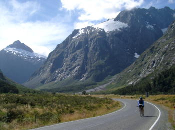
This is a great ride if you time it right. As described in Peddlers Paradise but the traffic is not bad. If you miss the tour Buses going in from 10 to 11AM or the same buses coming out from 3:30 to 5:00PM, it’s actually a quiet road. Recognize that these bus drivers are professionals so just give them room. Also, the car traffic is mostly rent a cars with courteous Europeans at the wheels. The tunnel is 2-lanes but the traffic goes through one way at a time. Going to Milford you can easily make it through since it slopes down. Its dark and wet. Going back you have to wait in the tunnel for a second line of traffic going your way. The climb and descent are steep at the top part of this climb.
Manapouri to Mossbrun 61Ks
Back out on Hwy to Tautapere for 5Ks then straight on road marked to Lumsden, quiet. Flat then slightly climbing to junction Hwy 94 at 17Ks, then right. Slow rise. Moderate but fast traffic. A narrow shoulder. Tail winds. Steeper for 2Ks to mini pass at 38Ks. Then gradually down a river valley to Mossburn at 61Ks. (with west wind it’s a fast ride)
Mossburn to Kingston 60Ks
Out on Hwy 97, north. No hills but gradually up to junction Hwy 6 at 20Ks. Left. Hwy 6 has moderate to light traffic but it travels fast. Tour buses pass before 9AM or after 5PM. Few trucks. All grades are gradual. Much better than presented in Peddler’s Paradise.
Kingston to Queenstown 47Ks
Along lake, some ups and downs, sometimes narrow. Still moderate traffic. Last 6Ks into Queenstown is on a hilly bike path.
Queenstown to Wanaka 77Ks
First to Arrowtown, 21Ks by the back road. Narrow road with some traffic. Thru the gorge then Hwy 6 to the turn on Hwy 89 at 25Ks. Steep switch back climb for 3Ks then rolling then steep again to top (11.5Ks from turn to top) at 37Ks. Steep down to 40Ks then gradual down a valley (watch the river grow). At 54Ks, the Bra fence. All sizes and marked down. Try one on. Into Wanaka at 77Ks.
Wanaka toward Mt Aspiring 44Ks round trip (side trip)
On paved road to end, 22Ks. Narrow with some traffic including trucks. Very good views. After 22 Ks, it’s a gravel road for another 30Ks if you choose.
Wanaka to Makarora 64Ks
Out 2Ks to Wanaka junction on busy road then left on Hwy 6. Hwy 6 is busy in AM with tourist traffic, especially to Hawea at 15Ks. Hilly 2-lanes with negligible shoulder. Quieter as you go. Great Scenery. We had winds from the east in AM but they became westerlies in late AM. Along the lakes, you are exposed to the winds. Store & restaurant at 60Ks.
Makarora to Haast 82Ks
Thru here you get protection from the winds before the pass. Great scenery. Start up to pass at 15Ks, steeper as you go. Top at 18.5Ks. Gradual down to 27Ks then down steep for 1.5Ks to bridge then gradual down for 5Ks. Finally down a valley, very gradual to Haast Junction.
Haast to Fox Glacier Village 120Ks
Across long bridge, 300 meters. 2-lanes, no shoulder. Tourist traffic. No trucks but some buses. Frequently only so-so scenery. Good sea views at 28Ks at look out. Glimpses of Mt Cook. Many interesting and sometimes long one lane bridges. Food and restaurants at 58Ks (The Salmon Farm). No other food available until Fox Glacier Village. Along the coast around Bruce Bay. With straight west winds, going inland is a following wind and toward the sea is a head wind as the road heads in and out.
Fox Glacier Village to Lake Matheson 9Ks (round-trip)
Great views of Mt Cook, Mt Tasman etc. on the way to “the” view. Easy.
Fox Glacier Village to view Fox Glacier 11Ks (round-trip)
Back to turn-off, then good dirt road to parking then, walk 1K to Glacier.
Fox Glacier Village to Franz Josef Village 24Ks
Immediately climb 4Ks, some moderate, some steeper grades. Steep windy down to 6.5Ks then climb again. Moderate to steep to 10Ks then down again. Light traffic, no great views. Moderate grades down to 12Ks. Then up. Good scenery through here. Gradual climb to 15Ks then moderately down to 18Ks then a gradual climb to town.
Franz Josef Village to Franz Josef Glacier 10Ks round-trip
South to turn, left, then up a gradual, dusty, gravel road with a lot of tourist traffic. Then walk 2 hours to Glacier or 15 minutes to the viewing platform.
Franz Josef Village to Hari Hari 63Ks
Easy grades, mostly flat along the mountains. 2-lanes, no shoulder, light traffic, mostly tourists, a few trucks, some good views. One climb, gradual then steeper to 52Ks. Moderate descent for 3Ks then flat to Hari Hari, 63ks.
Hari Hari to Hokitika 71Ks
2-lanes, no shoulder, hilly and so so scenery. Too much tourist traffic. After Ross it flattens out and is straight with a narrow shoulder. Dull scenery. Its imperative to have a tailwind to enjoy this (we had a tailwind)
Hokitika to Greymouth 40Ks
Flat for 21Ks to Kumara, 2-lanes. Sometimes a narrow shoulder. (Now (3/05) they are widening the road.) So so sea views, moderate traffic, more trucks. After Kumara junction, 2-lanes with a wide shoulder, more traffic and trucks, poor industrial scenery. There are some side roads into the town center.
Greymouth to Punakaiki 45Ks
2-lanes, no shoulder, inland for 10Ks. Much less traffic and trucks. Rollercoaster hills along beautiful coast to Barrytown (pub) at 27Ks. Then it flattens out until the last 4Ks. At 43Ks, the Pancake rocks and blowholes. Some trucks and some tourist traffic.
Punakaiki to Westport
2-lanes, no shoulder, light tourist traffic. Climb Perpendicular point. It’s only a moderate climb then gradual with excellent sea coast views. Top at 3.5Ks then a steeper descent. Then along the spectacular coast to 16Ks. Then climb inland for 4.5Ks. Some steep, some moderate, some gradual. Gradual down and some steep up to 24Ks. Down and up to 26Ks. Distant sea views. Gradual descent to Charleston at 30Ks. A few steep short hills then a gradual climb to 43Ks then gradually down at 46Ks, go past the turn for Cape Foulwind (12Ks). Straight to junction Hwy 67 at 50Ks. At junction, toward town on a busier road.
Westport to Murchison 98Ks
6Ks back to junction then Hwy 6. 2-lanes, no shoulder, light traffic, some trucks, Kiwi traffic (they pass too close). At 33Ks, Berlins then Inangahua at 48Ks. Good scenery through the gorges. Easy rolling hills up the river. Swirling winds or calm. At 60Ks, cross the river and climb (moderate mostly) to 65Ks then steeper climbs and descents on a narrower, windy road to New Bridge at 80Ks. Then more gradual. Junction at 86Ks, left on Hwy 6. Tailwinds here. Gradual rise to town, 98Ks.
Murchison to St Arnaud 60Ks
Continue up the Buller River. A steady climb, 2-lanes, a sometime narrow shoulder, light traffic but some trucks. Nice scenery. Tailwind. At 35Ks, junction Hwy 67, right. Less traffic. More steady climbing. Last 15Ks are on the “Flat road that isn’t”. It looks easy but you’re in your low gears. Cross to tailwind through the wide valley. (In 2 days from the mouth of the Buller river to its head waters.)
St. Arnaud to Motueka 125Ks
Alternate route over Hope Saddle, 25Ks back (now down) to junction with Hwy 67 then right 14Ks climb to Hope Saddle at 39Ks. Steep last 5Ks then down. Great views. More gradual as you descend to Kohatu at 65Ks. Light to moderate traffic, with trucks, 2-lanes, no shoulder. From Kohatu to Motueka it’s 60Ks as described in next section.
St Arnaud to Motueka 106Ks
Up 4Ks, then left Now descending, 2-lanes, quiet, ordinary scenery and occasional short climb. At 18Ks, start mostly moderate climb to 21.5Ks then down and more down to 35Ks left on Valley road. Thru Tree plantations so a few logging trucks. At 43Ks junction right to Hwy 6 then quick left (toward Murchison) then at 46Ks, right on Motueka Valley Highway. Still down. 2-lanes, some tourist traffic and some logging trucks, light to moderate traffic, at 54Ks, Tapawere. Narrow 2-lanes, no shoulder O.K. scenery. At 59Ks, a steep 1K climb then continues down. At 72Ks left and over bridge to Westbank road. Left at 84Ks, Peninsula Road (you can go back to the bridge back to Motueka Valley Highway, 20Ks to Motueka) straight is 22Ks to Motueka on the west bank of the river. At 90Ks, another possible bridge to highway. At 100Ks right on Old Mill road. Take the first left then first right at 101Ks. Narrow busy road to Hwy 60 at 103Ks. Straight onto Hwy 60, busy. Across bridge at 104Ks on cycle path. Then a hairy 2Ks into town on busy narrow road. (See below for direct route from Motueka to Picton.)
Motueka to Kaiteriteri 13Ks
Back out Hwy 60, busy, 2-lanes and flat to 7Ks. Right to Kaiteriteri, 2-lanes, light traffic to 9Ks then windy and hilly to town. Good views.
Kaiteriteri to Takaka 56Ks
Out to Hwy 60, 6Ks then 3Ks to start of 11K climb to 20Ks. Moderate grades, 2-lanes often narrow, light traffic but some big vehicles. A couple dips but climb to 24Ks, Takaka Hill 791 meters. Steeper down to 34Ks. Narrow but some new wider parts. Great vistas up and down the pass then mostly flat. Wider and sometimes a narrow shoulder. Headwinds. Through a ranching valley.
Takaka to Totaranui 34Ks
(It might be possible to get a water taxi with bike to Totaranui from Kaiteriteri)
Out road to Pohara on a fairly busy road, 2-lanes, mostly flat until a 2K climb and 2K descent at 15Ks. Road is now quiet after Pohara. Sealed road ends at 22 Ks then rough gravel. It is a tough climb and descent to Totaranui (we did not ride this gravel part)
Takaka to Farwell Spit 51Ks
Out Hwy 60. Some short steep climbs to 22Ks then flat past Collingswood. Along the bay on narrow , scenic, quiet road to end of tarmac at 50Ks then a rough gravel road for 1K to the Info Center for Farwell Spit.
Farwell Spit to St Arnaud
Retrace routes described above
From St. Arnaud to Blenheim 105Ks
5Ks back up Hwy 63 to junction for road to Nelson. Straight. 2-lane starts down. Moderate grades. Light traffic. Down a widening valley. Nice scenery. After 25Ks, gradual and straight. Winds turn easterly in PM. At 91Ks, thru vineyards, flat, more traffic. From Renwick, there are 4 options. Hwy 6, Old Renwick road, New Renwick Road or Rapaura Rd. 13Ks, some a bit longer, all with some traffic. Flat. Usually easterly winds in PM.
Blenheim to Picton
(described earlier as Picton to Blenheim) Alternative route to Picton.
Moteuka to Nelson via Upper Moutere Hwy 56Ks
Climb gradually for 20Ks to Upper Moutere then a harder climb for 6Ks to top at 26Ks. 2-lanes, light to moderate traffic, some trucks, no shoulder. This is actually a nice ride. Nice scenery. Moderate then gradual descent into valley for 6Ks. At 34Ks, Hwy 60. Busy with shoulder (via Hwy 60, 29Ks to Motueka) right. Over narrow 2-lane bridge. (300 meters) then left at 36Ks on Landsdowne Road then right into Richmond through industry. Lots of trucks. 2-lanes to Hwy 6 at 42Ks. Right on busy road with shoulder. At 44Ks, bike path along the coast. Follow signs to center and consult Peddler’s Paradise. (It’s a good way into the city)
Nelson to Havelock 74Ks
(Usually westerly winds but today easterlies)
12Ks flat along coast, wide road with good shoulder, moderate traffic, a lot of trucks. Uninteresting coastal scenery. Climb 1K to Gentle Annie Saddle (90 meters) at 13Ks. Down to Hira at 14Ks then gradual rise to 17Ks then moderate grades to 23Ks. The shoulder desists up and down the Whangamoa Saddle. So so scenery. Watch out for trucks. Steeper down for 3Ks then rolling and gradual to 35Ks. Far safer road. Straighter, newer and usually with a shoulder after the Saddle. Start up gradual then1.5Ks steep to Rai Saddle at 41Ks. Down to Rai Valley at 46Ks then gradual and rolling to Pelorus Bridge at 55Ks. Road often has a shoulder and is generally easier to see traffic coming (Its straighter) Gradual rolling to Canvastown at 64Ks. More traffic and trucks as the day goes on. Fast moving and bunched up behind trucks. Nice scenery. Gradual rolling into Havelock at 74Ks.
Havelock to Picton 35Ks
Winds start easterly but switch to westerly. 1K on Hwy 6 then left and gradually climb to 4Ks. Good views. 2-lanes, narrow, no shoulder. Only a few trucks early on and light traffic. Nice gradual down then flat through Linkwater to the Grane at 18Ks. Now along on Charlotte Sound. Road becomes narrower. Beautiful. At 21Ks start hills. Moderate or gradual thru a climb to 30Ks. Twisty narrow road. The traffic is slow moving so its very safe riding. One more will then Picton 35Ks.
Picton to Wellington by ferry (end of trip)
Road Stories
E-mails from New Zealand January, February and March 2005
We finally looked at a globe. New Zealand is farther south than Cape Town So Africa and the same as Southern Chile and Patagonia. We are the same latitude south as Milwaukee is north. The climate is similar to Washington and Oregon and so is some of the scenery. We made our way slowly down to Wellington because the weather was very fine. We met a Swiss couple who told us about a back road that had no traffic. The area was vineyards and ranches where we watched them sheer sheep (1 minute to sheer a sheep and each man can do 300 a day), saw a sheep dog trial (last years winner was there) and an air show – the crowd was about 4,000 – not exactly Oshkosh which is about 400,000 and no one died (every summer someone dies at the air show in Oshkosh).
Before we left we talked to Jason Shimko who had just returned from biking in New Zealand. He told us that the peninsulas are the bicycling highlights. We started in the Coromandel Peninsula but our timing was bad. All of Auckland was there and the weather was poor. We tried again on the East Cape Peninsula and this time Jason’s advice paid-off. Five days of world class coastal biking, quiet roads, Big Sur scenery but we still fought wind, rain or cold. Now in Gisborne – the weather is finally “fining-up” as they say. This town is reputed to be the warmest place in New Zealand and is the 1st city in the world to see the sunrise (close to the international date-line). The city did a big promotion over the millennium and people flocked here from all over the world to see the first millennium sunrise. It rained like hell that day!
The Tsunami looms over everyone. Talk radio here is full of “How can we do more to help?” But it’s Holiday Time in New Zealand. How can there be 5 million cars when only 4 million people live here? Are the sheep driving? Everyone is on a road trip this time of year. We arrived in Auckland and found most places closed till Jan. 10. We took a commuter ferry out of town. They told us they are are always full (250 passesngers) – we were alone. The Coromandal Penninsula – usually quiet was bumper to bumper with cars totting toys (boats, campers etc.) We are now in Rotorua – which literally stinks with thermal sulphur pools. A few more days and the currently frantic New Zealand will settle down. Best to all in 2005! Peter & Sally By now you’re getting the drift that this is a “quiet” place. We have had no warnings about local bandits or told, “you are guaranteed to be robbed if you hike that volcano” (as in Guatemala). The best the Kiwis can say is “be careful” which is code that there are Maori living in that area. There are 4 million Kiwis, 38% live in Auckland, 3% are Maori. The Maori are the aborigines and very much like our American Indian. One day I was sitting with the bikes at a lake. Peter was out gathering information. A young man Maori, wearing a loincloth, with thick black rectangular tattoos all over his body and face was twirling a spear to promote a local show for tourists. He spotted me and came over asking, “Where are you riding?” I told him. He said, “I started riding a bike and after the hills of the East Cape I bought a car.” Not exactly threatening.
Our biggest challenge is the hills, winds and rain. We now know where to stay – Motels. The heavy tourist season at the beginning of our trip has driven us to use all types of lodging. They are all clean. Backpackers – small and basic. Hotels – small rooms. B & B’s – too fussy. Motels, usually run by a Ma & Pa team, have large rooms, sometimes two, with kitchenettes and offer free use of a washer and dryer. This has come in very handy when we arrive soaked to the bone. The best part is they traditionally give you a carton of milk when you check in – for a spot of tea or coffee, of course. We are taking the ferry to the South Island today. Everyone on the North Island says, “The people are really nice on the South Island”. We are wondering how they can get any better.
Ekatahuna in the North Island. EK we found out is the brunt of every “dumb” joke in New Zealand. The Kiwis have a self-effacing sense of humor. On the Pub/Hotel the sign reads “Ekatawhere…….Ekatahere” We spent a Sat. night there and the farm boys were all wearing recently washed t-shirts. Two “Britney Spears” Dutch girls arrived for the night. This sent the bar into a dither. Every young man was love struck, stammering and bumbling. We just sat back and enjoyed the show. They boys were fortifying themselves with beer to develop personality and self-esteem while the girls aptly picked and choose who would buy them the next beer and whipped them all at pool. In the South Island – Middlemarch. Every Easter there is the “Bachelor’s Ball”. There are lots many men in this area but no women. So on the night of the “Ball” the train arrives from Dunedin with 500 women. These women are from all over the world. Yes, the US too. The locals are in the bar early in the afternoon and are well on their way when the train arrives. They set up a tent for dinner and dancing. The train takes all the women back at 1AM. We asked if any long-term relationships or marriages result. “Yep, there was one marriage about 4 years ago.”
Last night as we arrived in Methvan, population 300- a ski town in winter- nothing in summer, Peter had a problem with his bike. Mat and Dorothy, fellow cyclist from Virginia and former bike shop owners, were staying at our motel. Mat told Peter that the left cup on the lower bracket was loose. (Greek to us) It can only be fixed with a special tool – which is one of the few tools that Mat does not carry. The nearest bike shop is Christchurch – we left there two days ago. There is no public transportation, no car rentals.
Peter did what every self respecting cyclists would do – he went to the Pub. Outside the pub there were several Mountain bikes parked. In the pub Peter found the group of riders, “Anyone here know how to fix a bike?” Several shouted and pointed to, “Big Al”. Big Al was bald, tan, very tall with very big muscles and was busy drinking with his pals. Big Al used to be a bike mechanic and now owns the local ski shop that is closed for the summer. He writes the 9A appointment with Peter on his arm in ink.
The next morning, Peter arrives at the ski shop and Big Al is waiting. Big Al takes a “cup” from one of his many bikes and fixes Peter’s bike. But Big Al wants this “cup” back when we get the bike properly fixed. This night, when we arrive in the next town, we see Mat and Dorothy. Mat closely examines the repair and declares it an excellent job. Self-reliant Mat asks Peter “How did you ever get this fixed in the middle of nowhere?” “BIG AL”.
That was 10 days ago and we are now in Dunedin. At Cycle Surgury we wanted to just buy Big Al a new cup, not understanding the mechanics of it all and wanting to take a short cut, but the bicycle mechanic after telling Peter “Don’t get smart with me” finally got it through to us that Big Al needs the original “cup” back. Peter bought a new “cup” for his bike and Big Al is getting back his used “cup”. In ever trusting New Zealand not to have concluded this arrangement would be a sac religion.
We are now in the West Coast of the South Island of NZ know as the Wop Wops (boondocks). Besides lots of tourists, there are lots of Sand Flys. Tiny, Nat-like but they bite. Some people are very susceptible – I’m not – Peter is! (Something to do with sugar consumption?) On our way down the Haast Pass entering the West Coast we met Miles, a Kiwi photographer for National Geographic. He was fascinating but Peter was in a black cloud of Sand Flys as soon as he stopped. Peter has to keep moving or get eaten alive. He starts circling Miles and I on his bike, “I’m still in the conversation,” he explains with the black swarm trailing his back. It’s easier to tell you where he doesn’t have welts: private parts, left ear lobe, right palm and 1 digit. He is now well invested in “RID” to stop them and “Scratchy & Itchy” to make the red welts tolerable. Even the Kiwi cyclist can’t believe all his bites. When he looks away we all have a good smerk. Can’t believe it’s already March.
The meager Kiwi population on the South Island is over whelmed by the seasonal tourist on slaught. We encounter gleaming tour buses, back-packer shuttles, camper vans, cars, hitch-hikers and, yes, cyclist. There are more cyclist here than any place we’ve been in the world. It does get in the way of the natural spectacle that is New Zealand. The tourists come to see the 50 wineries around Blenheim, the thousands of seals along the rocky northeast coast, the “Dusky” proposes play in the surf and propel out of the water, twirling white bellies in the sun. There are sparkling streams, waterfalls and deep clear glacial lakes with green pine forests hugging steep mountains that spike out of the lakes. Rock sediment colors the waters. The lake that worships snow covered Mount Cook – on that perfect day- was a deeper blue than the clear blue sky. Tourists come to hike the rainforests, coasts and glaciers. We feel tiny riding in this dramatic landscape. Straining into a fierce wind one day, and days later feeling the winds friendly hand on our backs pushing us up a wide valley. We adapted and book ahead so that all the, “No Vacancy” signs don’t apply to us anymore. This is a completely new and disliked procedure for us.
Normally Sunday is a quiet bike day- not here. The Kiwi’s are all returning from their hyperactive weekends. Their pursuits run from the standard, fishing, hiking and biking to sky diving, mountain climbing and white water kayaking. It’s no wonder these people invented the bungee jump. The most extreme was the wiry bartender we casually asked, “So what is your sport?”
His reply “Pig Hunting”.
“You mean wild pig hunting?”
“Yep, with dogs and knife.”
“How do you do that?”
“Well, Captain Cook let loose pigs when he stopped here so there would be a food supply on his return so there’s lots of em and have been for a long time. I got my “findem” dogs, and then I send in my “holdem” dogs, and next come my two half mastif, half pit bull dogs. I send them in when I’m ready. They each take an ear and “bind” the pig so I can rush in and slit the pigs throat in exactly the right place.”
“That sounds like a nice relaxing Sunday afternoon pursuit.” Replies Peter.
Pump Problems (1994 Trip to New Zealand)
We were on the west coast of the South Island and it was raining like hell. Sally, the realist, got a ride out over the mountains but I the optimist stayed behind to ride. My hope was that it might clear and I might finally get a glimpse of this mountain range, which had been obscured for days. It rained harder. In fact the gravel road I was on was washed out. The Kiwis are prepared for these things and soon a big earthmover appeared carried in a government truck. This machine would work feverishly for 15 minutes to make a land bridge, which lasted just long enough for 10 to 15 cars to cross. The stranded vehicles would scurry over and a worker would stop the next car just before the earth bridge would give way. After crossing I would always know when the cars were able to cross as 15 cars would pass me as I cycled through the rain. Now I have a flat and my pump fails. I’m stranded. I notice no more traffic. The earthmover must have quit for the day. I start walking and calculate that I’ll get to town sometime after midnight. I hear a truck. It is the truck carring the earthmover. Only in New Zealand would a government worker in a government truck stop and give a soaked cyclist a lift. Thank God.
P.S. Jerry, the owner of Rainbow Jersey, my bike shop in Milwaukee, gave me this piece of advice later. In the event that you are stuck without air you can render your bike rideable by tightly stuffing grass into the tire and putting it back on the rim. Since then I’ve carried a better quality pump.


